Biodiversity Museum Hyderabad is Institutional architectural project designed by SDAARCHITECT, located in Hyderabad, Telangana.
Project Info
| Client |
Creative Museum Designers Pvt Ltd |
|---|---|
| Project Type |
Institutional |
| State |
Telangana |
| City | Hyderabad |
| Team |
Sunando Dasgupta Swarnali Roy Ganesh Kholia |
| Status | Design Proposal |
| Scale | Large-Scale Projects |
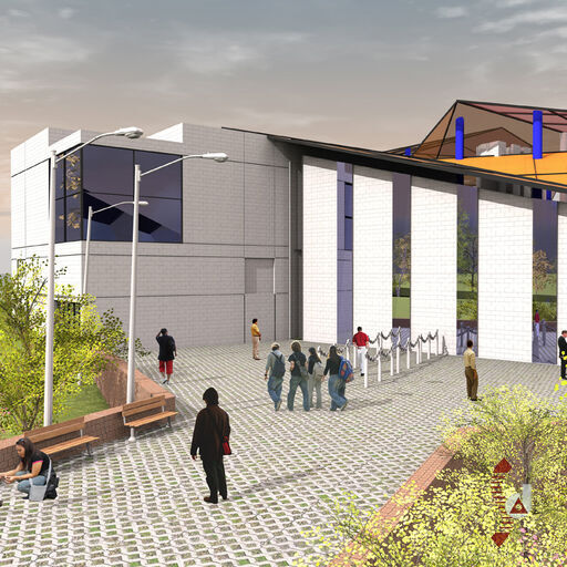
Architectural Renders

Site Analysis
Location and Context
The proposed site for the Biodiversity Museum is situated near the Cyber City of Hyderabad, within the campus of the National Biodiversity Park. It lies at the junction of the Old Mumbai highway and the Hi Tec City main road, covering approximately 20 acres.
The site is rectangular in shape, with dimensions of about 321 meters along the east-west direction and 180 meters along the north-south direction.
To the north, there is a proposed new road running alongside the site, linking it to the main road and other institutional plots being developed on the northern and eastern peripheries. To the south, the prestigious Cyber City of Hyderabad is situated on hilly terrain overlooking the proposed site.
On the eastern side of the plot, approximately 1 kilometer away, lies the Durgam Cheruvu lake, while the western side of the plot is adjacent to the Khajaguda Cherevu lake, which is immediately beyond the road junction. The Shilpa Gram craft village is located about 500 meters to the east.
The site faces existing commercial development along the Old Mumbai highway, with the junction being a busy thoroughfare.
The front portion of the park is developed with passive and active landscape zones. A central sculpture garden features a 32-feet-high elliptical Biodiversity Pylon, which depicts the evolution of species from an atom to human beings. The base of the pylon represents nature’s five elements: Earth (Prithvi), Air (Vayu), Water (Jala), Fire (Agni), and Ether (Akasha).
Along the northern boundary wall, there is a linear plantation of trees representing nearly all the countries of the world. The rear portion of the site is currently barren and slopes down into a slightly low-lying area, which then rises to a hilly formation at the rear. The geological formation of the hillock follows a linear direction along the north-south axis, with sporadic rock formations characteristic of the Deccan plateau.
Site Analysis & Design Morphology
The entire built-up structure of the museum has been planned over the depressed area, rising to the hillock at the rear side of the site. The design is responsive to the site's natural contours, with a contour difference of approximately 21 meters between the entrance area and the rear hillock.
Localized mounds on the site have been integrated into the design effectively. The lowest point on the southern boundary is proposed to be converted into a natural water collection reservoir, which will include an overflow system to drain excess water into the external drainage system.
The steep gorges and gentle slopes are utilized for additional facilities such as Science Parks, gardens, an open-air theatre, parking, and other amenities. The site layout involves optimized cutting and filling of land profiles to facilitate functional and cost-effective external development work.
A proposed road under construction along the northern boundary will link the main road to the rear end of the plot. The predominant east-west axis of the site connects peripheral roads, entrances, the sculpture garden, the pylon, and the main museum building.
The museum building blocks are designed to follow the natural site profile, with fragmentation to accommodate the site's contours and slopes. This approach breaks the rigidity of a linear axis with the apparent fragmentation of the museum building.
Access to the site includes two major points: a front vehicular access that transitions into a pedestrian walkway, and a rear vehicular access from an elevated side road. The front access connects to the main entrance level via a linear axis, with pedestrian pathways continuing to various facilities, including the observation deck, open-air theatre, water body, aquarium, and aviary dome.
Another rear vehicular access connects from a side road at an elevated level, providing access to the auditorium and service zones, with additional parking at level 570 for approximately 50 cars through a ramp.
Design Concept
Core Concept
The Biodiversity Museum is designed to be a celebration of biodiversity, science, and the art of nature. The concept revolves around creating an engaging and immersive experience that highlights the beauty and complexity of the natural world.
Development and Planning
The development of the Biodiversity Museum began with the submission of a draft base paper on the museum’s theme. Following this, the Ministry of Environment and Forests (MoEF) convened a meeting of experts from the Wildlife Institute of India (WII) with the CMD team to discuss the possible nature of the museum. CMD also presented a brief on the development plan, and the first meeting of the Technical Committee for the National Biodiversity Museum was held on 8th July 2014 in Hyderabad, where CMD presented two alternative development plans.
The Technical Committee provided suggestions and action points for the development of the first draft of the Detailed Project Report (DPR). The current First Draft of the DPR reflects the discussions and guidelines established during this initial meeting.
Project Scope and Facilities
The museum will be constructed over an area of approximately 17,000 square meters, within a 20-acre site. The project includes the establishment of nine thematic galleries and an outdoor biodiversity park. The total area envisioned for the project is around 51,953 square meters, with an estimated cost of 160 crore INR.
Architectural Approach
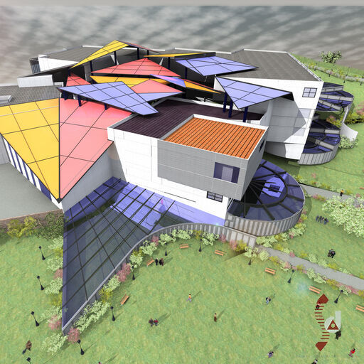
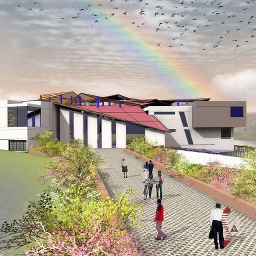
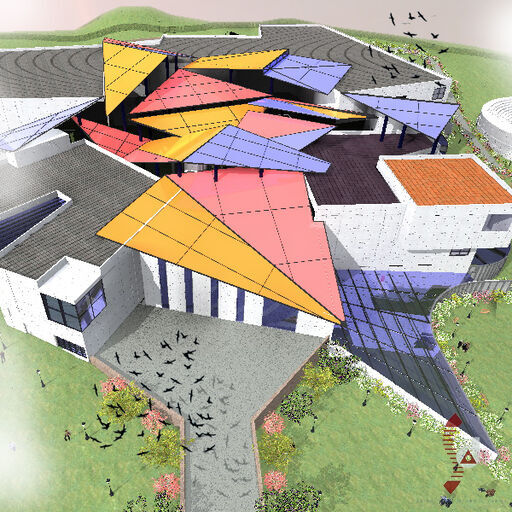
The architectural approach for the museum integrates the natural profile of the site, with efforts to develop a design that responds to the site’s topography. The design features a fragmented building block arrangement that follows the contours and slopes of the site, creating a dynamic and visually interesting experience.
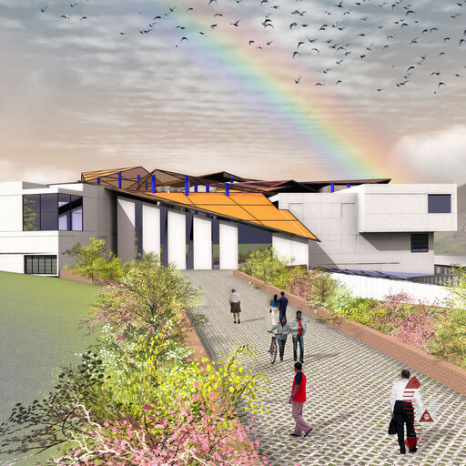
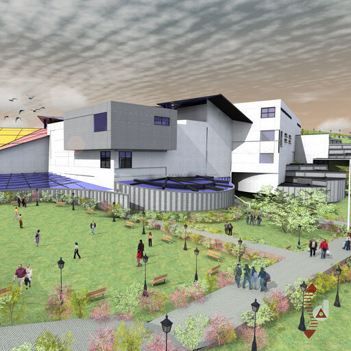
The design incorporates both solid and transparent roof forms supported by steel structures, which not only provide shelter but also create a unique visual effect with light and shade. This design strategy allows for the display of large suspended exhibits and enhances the overall visitor experience.
Integration with Natural Features
The museum’s design integrates various natural features of the site, including the surrounding hills and existing water bodies. The layout aims to harmonize with the site’s natural contours, utilizing steep slopes and low-lying areas to enhance the functional and aesthetic aspects of the museum.
The design also emphasizes sustainability and environmental consciousness, with features like rainwater harvesting, efficient water management systems, and energy-efficient measures, all contributing to the museum's goal of celebrating and preserving biodiversity.
Site Layout
Overall Site Dimensions
The Biodiversity Museum site is situated near the Cyber City of Hyderabad, covering approximately 20 acres. The site is rectangular, with dimensions of about 321 meters in the east-west direction and 180 meters in the north-south direction.
Context and Surroundings
The site is located along the junction of the old Mumbai highway and Hi-Tech City main road. To the north, there is a proposed new road connecting the site to the main road and surrounding institutional plots. The southern side of the site faces the prestigious Cyber City of Hyderabad, situated on a hilly terrain that overlooks the museum site.
On the eastern side of the site, about a kilometer away, lies the Durgam Cheruvu lake, while the Khajaguda Cherevu lake is situated on the western end, immediately after the road junction. The Shilpa Gram craft village is located approximately 500 meters to the east of the site. Additionally, the Old Mumbai highway features existing commercial developments, and the area around the junction is a busy thoroughfare.
Site Features and Terrain
The site’s front side is developed with passive and active landscape zones, including a sculpture garden featuring a 32-feet-high elliptical Biodiversity Pylon. The pylon represents the evolution of species from atoms to intelligent human beings and is composed of concentric circles symbolizing the five elements: Earth, Air, Water, Fire, and Ether.
Along the northern boundary wall, there is a linear plantation of trees representing various countries around the world. The rear portion of the site is currently barren, sloping down into a low-lying area and rising to a hilly formation at the back. The geological formation of the hillock runs in a north-south direction, with sporadic rock formations characteristic of the Deccan plateau.
Contouring and Drainage
The site has a contour difference of approximately 21 meters between the entrance area and the rear hillock. The entire built-up structure of the museum is planned over the depressed area, rising to the hillock at the rear. The design makes use of localized mounds and integrates them effectively into the overall layout.
The lowest point on the southern boundary will be converted into a natural water collection reservoir with an overflow system to manage excess water. Steep gorges and gentle slopes are utilized for additional facilities such as science parks, gardens, and an open-air theatre. The design aims to optimize land cutting and filling to achieve functional and cost-effective development.
Access and Circulation
The site includes two major access points to the museum building. The main entrance from the road features a vehicular route that transitions into a pedestrian walkway. This path connects the parking zone to the main entrance and continues around the museum building, ascending to the rear hillock level through a ramp. The pedestrian pathway forms a loop around the building, linking various facilities including the observation deck, open-air theatre, water body, and aviary dome.
A secondary rear vehicular access connects to the auditorium and service zones from an elevated side road, providing additional parking space and access to various museum functions. This entrance leads to a parking area at level 570, accommodating approximately 50 cars.
Functional Layout
Main Museum Building
The main museum building is designed across multiple levels to accommodate various functional areas and exhibit spaces while integrating with the site's natural contours.
Entrance Level (573 meters)
The entrance level is situated at approximately 573 meters, which is about 1.5 to 2.0 meters above the pylon area. This level features a large ceremonial ramp leading from the pylon area to the main entrance foyer. The central planning feature of this level is a large semi-open space surrounded by exhibition halls and a central circulation node.
Four exhibition halls are located at this level:
- Hall 1: 769 square meters
- Hall 2: 927 square meters
- Hall 3: 650 square meters
- Hall 4: 650 square meters
Additional facilities on this level include the 3D Theatre and the Digital Interpretation Centre. The floor plate is equipped with staircases, lifts, and toilets as per norms. A large central quadrangle is covered by a diverse roof structure, allowing for the display of large suspended exhibits and creating an interesting visual vista for visitors.
Lower Ground Level (Average Level 569 meters)
The lower ground level flows out towards the southern side of the plot, incorporating external exhibits like huts and dioramas. This area connects with the greenhouse and butterfly garden, and includes a parking lot for around 32 cars. The butterfly garden steps up along the natural contours of the hillside at the rear.
This level includes five additional exhibition halls:
- Hall 5: 839 square meters
- Hall 6: 605 square meters
- Hall 7: 650 square meters
- Hall 8: 650 square meters
- Hall 9: 720 square meters
A deck behind Hall 8 will house a food court, with stairs connecting to the pedestrian precinct. Hall 6 includes an auditorium with its stage and green room, accessible via a cul-de-sac from the entry road at the 576-meter level.
Level 583 meters
This level comprises the service and activity areas of the museum complex. It includes:
- The auditorium block and student activity area on the northern side, including the Library, Workshop, Laboratory, Training Centre, and Computer Centre.
- The Temporary Exhibition Hall and three Conference Halls, connected through a large entrance lobby and service road.
- Workshop, Stores, and Office block on the southern side, with access to the loading/unloading lobby for the Temporary Exhibition Hall.
There is also a vertical link via goods lifts and service stairs connecting the workshop and stores with all the halls across various levels. Open terraces are proposed over Hall 5 and Hall 9.
Roof Level
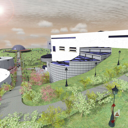
The roof level features a myriad of roof forms with colored opaque and transparent sheets supported by steel structures. This design reflects the diversity of life forms found in India. The roof is partially open to allow natural air circulation and rainwater collection. It is designed for maintenance access as needed.
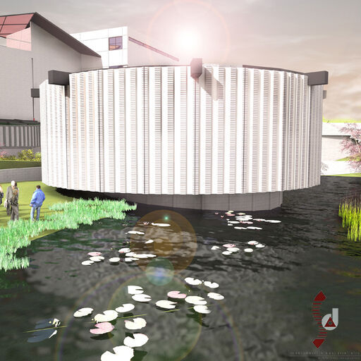
Waterbody and Aquarium
A large water body is planned at the southern side of the plot, utilizing a natural depression to create a reservoir. This will serve as a catchment area for rainwater and include a natural and fresh water aquarium. Pedestrian pathways will connect the water body to the main museum precinct.
Open Air Theatre
An Open Air Theatre (OAT) is proposed adjacent to the water body, fitting well with the site's contours. This facility will be used for recreational and educational performances and shows.
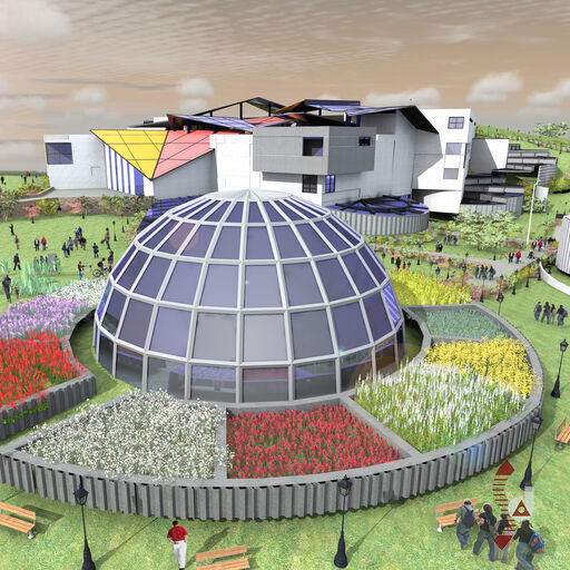
Aviary Dome
An Aviary Dome is planned over a natural mound, designed as a geodesic dome structure with circulation paths surrounding it. This area will also include a maze garden.
Cacti Garden and Bamboo Grove
Additional features in the biodiversity park include a Cacti Garden and a Bamboo Grove, integrated with the pylon area to enhance the overall development.
Movement and Circulation
Overall Access Points
The Biodiversity Museum is designed with two primary access points to facilitate visitor movement and service access:
Frontal Access
The main entrance to the museum is located along the main road and includes a vehicular route that transitions into a pedestrian walkway. This route leads visitors from the parking zone through the main entrance foyer and continues along a linear axis to connect with the museum's central areas. This pathway also connects to the rear access, forming a loop that guides visitors around various facilities, including the observation deck, open-air theatre, water body, aquarium, aviary dome, and maze garden.
Rear Vehicular Access
A secondary vehicular entrance is proposed from a side road at an elevated level. This entrance provides access to the auditorium, temporary exhibition hall, workshops, and service zones. It includes parking space at level 570, accommodating approximately 50 cars, with access provided via a ramp.
Pedestrian Circulation
The museum's design emphasizes seamless pedestrian circulation, integrating various levels and facilities with carefully planned pathways:
Ground and Lower Ground Levels
At the entrance level, visitors can navigate through a ceremonial ramp leading from the pylon area to the main entrance foyer. The pedestrian pathway then continues alongside the main building, rising to the rear hillock levels via a ramp. This pathway forms a continuous loop around the building, providing access to the butterfly garden, water body, and other outdoor facilities. The lower ground level, which includes external exhibits and parking, connects with the greenhouse and butterfly garden, facilitating easy movement across different areas.
Upper Levels
On the upper levels, including the auditorium and service areas, movement is designed to be efficient and accessible. The vertical circulation between levels is managed through staircases, lifts, and ramps, ensuring smooth access for all visitors. The service core also includes goods lifts and service stairs connecting various functional areas across the different levels of the museum.
Special Considerations
The design incorporates several special features to enhance visitor experience and accessibility:
Access for Differently-Abled Individuals
Ramps with appropriate slopes connect various levels throughout the contoured site. Elevators are equipped with braille and audio assistance. Toilets are strategically located for easy access, and reserved parking spaces are provided for differently-abled visitors.
Integration with Natural Terrain
The museum's movement and circulation plan is closely integrated with the natural terrain. Contoured pathways and ramps follow the site's slopes, minimizing disruption to the natural landscape and providing an engaging experience for visitors. The design ensures that natural features, such as the water body and green spaces, are seamlessly connected with the built environment.
Visitor Flow
Visitor flow is managed through clearly defined pathways and access points, ensuring a smooth and intuitive experience. The design of circulation routes helps guide visitors from the entrance through various exhibit areas and amenities, ultimately leading them back to the main entrance or other exit points.